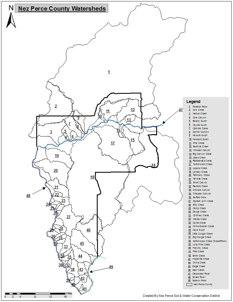
Hatwai Creek is a tributary of the Clearwater River and is located 3 miles east of Lewiston, Idaho. The watershed consists of 19,785 acres of land including: cropland (56%), range (31.5%), pasture/hayland (5%), riparian areas (2.5%), roads (2%), forestland (1%), mining areas (1%), and farms or suburban areas (1%). Fourteen percent of the watershed is located in Whitman County, Washington, with the remainder in Nez Perce County, Idaho. Of the Idaho portion, another 14% of the watershed is located within the Nez Perce Tribe Reservation boundaries. Hatwai Creek is shown as number 3 in figure 1.
Figure 1. Hatwai Creek Watershed.

Hatwai Creek watershed ranges from 775 feet to 2,964 feet in elevation. Annual precipitation is 10 inches at lower elevations and 22 inches at higher elevations. The geology is basalt with soils ranging from silt loam to sandy loam. Historically, the area has been utilized for crops, grazing, recreation, and mining. Historic or past grazing activities include dairies, large scale feedlot operations, and small scale horse and cattle operations.
A number of channel modifications occurred in the 1960’s. Historic photographs and interviews with land owners indicate that most riparian vegetation along Hatwai Creek was removed prior to 1960. The stream was straightened, the flood plain areas leveled and smoothed.
Historically, the Steelhead used Hatwai Creek as spawning and rearing waters before adverse impacts from human activities degraded their habitat. The 1988 Idaho Department of Water Resources - Division of Environmental Quality (DEQ), Idaho Water Quality Status Report and Non-point Source Assessment indicated that the beneficial use of salmonid spawning is not supported along Hatwai Creek. However, Hatwai Creek does have the potential to support Steelhead if habitat conditions are enhanced. Major factors limiting Hatwai Creek’s fisheries resource include high water temperature, low mid-summer flows, sedimentation of spawning and rearing areas, and a lack of riparian vegetation. Fish surveys conducted by the Idaho Department of Fish & Game show that Steelhead utilize the stream but their use is impaired by lack of habitat. The District is specifically concerned about the NPS pollutants from Hatwai Creek and their potential impact on the listed endangered species, Fall Chinook Salmon and Steelhead.
To view the Hatwai Creek documents go to our
Publications page.
Beneficial Uses
The beneficial uses of Hatwai Creek and the support status of each use, outlined in the 1988 (DEQ) Idaho Water Quality Status Report and Nonpoint Source Assessment, are listed below:
| Beneficial Use | *Status |
| Agricultural Water Supply | 3 |
| Primary Contact Recreation | 1 |
| Secondary Contact Recreation | 2 |
| Cold Water Biota | 2 |
| Salmonid Spawning | 1 |
*1-Not Supported, 2-Partially Supported, 3-Supported but Potentially at Risk
NPS Pollutants
Nonpoint source pollutants include sediments, nutrients, water temperature, bacteria, and hydrologic modifications that impair natural stream functions. Visual inspections and ongoing monitoring indicated the primary nonpoint pollution sources are streambank erosion, non-irrigated cropland (headwater sites), grazing activities, surface mining operations, and some timber harvesting activities.
Effects of Pollutants
The following impacts and effects result from the hydrological modifications in the water system:
- A decline in fisheries population due to seasonal temperature extremes, low flows, and the lack of instream structure and habitat diversity.
- A decline in agricultural water supply due to extremely low mid-summer waterflows and mining activity water consumption.
- A decline in secondary contact recreational use such as wading and fishing.
- A reduction in wildlife populations and in species diversity due to riparian, wetland, and upland habitat loss.
- Agricultural yield losses due to erosion.
- Crop damages and losses due to sedimentation.
The major limiting factors affecting Hatwai Creek’s fisheries resource include high water temperature, low mid-summer flows, sedimentation of spawning and rearing areas and lack of riparian vegetation.
Also fish surveys conducted by Idaho Fish & Game show that Steelhead utilize the stream but are impaired by lack of habitat. The District is concerned about the NPS pollutants from Hatwai Creek and their potential impact on the listed endangered species, Fall Chinook Salmon.
Land Use
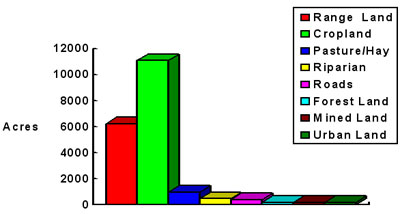
Cropland is the major land use within the watershed (56%). Other land uses include:
| Cropland (56%) | 11,080 |
| Pasture/Hayland (5%) | 989 | |
| Riparian (2.5%) | 494 | |
| Roads (2%) | 396 | |
| Mined Land (1%) | 198 | |
| Forest (1%) | 198 | |
| Range (31.5%) | 6,232 | |
| Urban Land/ Farmsteads (1%) | 198 | |
| Total | 19,785 | acres |
Wetlands
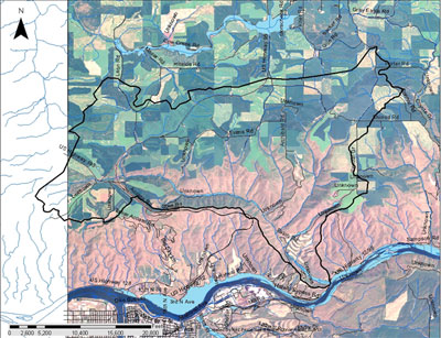
The USDA Soil Survey for Lewis/Nez Perce counties was used to determine the extent of hydric soils within the watershed. Approximately 236 acres were identified and are illustrated in figure 2.
Figure 2. Hatwai Creek Hydric Soils.

Figure 3. Hatwai Creek Land Use.

Farm Demographics
| Number of farms: | 22 |
| Number of low income:
or minority farms: | 8 | | Type of Farms: | Small Grain, Livestock | | Number of Farms by Type: | 20 small grain farms, 2 livestock operations | | Small Grain operation average size: | 800 acres | | Livestock operation average size: | 450 acres |
Ecological Data
| Annual Precipitation: | 12 to 18 inches |
| Soils: | Palouse/Athena/Naff | | Geology: | Basalt | | Threatened/Endangered Species: | Bald Eagle | | Plant Resources | | Trees | Douglas Fir, Ponderosa Pine, Cottonwood, Alder | | Condition: | Poor distribution and numbers of conifers. Large deciduous trees are low in vigor with few young trees. | | Acres: | 198 | | Grass | Native species include bluebunch wheatgrass and Idaho Fescue. Introduced species include intermediate wheatgrass, smooth bromegrass, and timothy. | | Acres: | 7,300 | | Range Condition: | Poor to fair. Trend is downward to static. |