One of the five objectives identified in the Catholic Creek Watershed Management Plan is to reduce stream temperature
Objective Description:
Reduce water temperatures to levels meeting applicable water quality standards for life stage specific needs of anadromous and native resident fish, with an established upward trend in the number of stream miles meeting standards. The benchmark for this objective is to reduce overall days exceeding daily average temperatures at less than 16 degrees Celsius for spawning and rearing for anadromous salmonids and less than 20 degrees Celsius under all circumstances (NPCC 1994). Additional benchmarks for specific project types are discussed under relevant deliverables. Desired out comes include restoring hydrologic functions related to temperature--identifying and rehabilitating wetland and floodplain areas, restoring riparian functions related to temperature--continuing efforts aimed at increasing streamside shading where streamside shading has been reduced by anthropogenic activities.
Deliverables:
In order to meet this objective one deliverable or treatment was identified:
Deliverable 1 – Improve Riparian Condition
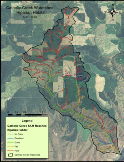
Priorities outlined in the Catholic Creek Watershed Management Plan will guide restoration efforts targeting riparian treatments in areas designated as poor or fair condition. Management criteria are based on the NOAA Matrix of Pathways and Indicators (NOAA, 1996). These include water temperature of 16°C, adequate sources of woody debris recruitment, and bank erosion of <10%. The geographic areas with the highest susceptibility to erosion are highlighted in red or orange in figure 1.
Figure 1. Riparian Treatment locations.

Reaches with poor and fair riparian habitat were identified for treatment. Impairment is defined as those reaches with less than 50% canopy cover, less than one active channel width of natural vegetation, a lack of vegetative regeneration, and/or moderately compromised filtering function. Impaired areas typically have invasive weeds, a lack of vegetative density, either grazing or agricultural tillage operations adjacent to channel, and minimal to no vegetative buffer. Reaches identified as poor and fair are recommended for improvements to reach a good or excellent condition. Figure 1 illustrates the locations for poor and fair rated reaches. An estimated 33.5 miles is identified for treatment.
Treatments include establishment of grass buffers, grass waterways, planting trees/shrubs and reducing livestock impacts to the stream. Livestock projects may include fencing, off-stream water developments and grass seeding.