One of the five objectives identified in the Catholic Creek Watershed Management Plan is to decrease sediment load.
Objective Description:
Reduce instream sedimentation to levels meeting applicable water quality standards, with an established upward trend in the number of stream miles meeting standards. Benchmarks for this activity include stream banks are >90% stable, < 20% cobble embeddedness, and turbidity is low (NOAA, 1996). Additional benchmarks for specific project types are discussed under relevant deliverables. Desired outcomes include restoring stream bank condition, reducing sediment delivery to the stream from hydrologically connected roads and uplands, and reducing sediment inputs by implementing practices that address problems from agricultural and other historic and current sediment producing activities.
Deliverables:
In order to meet these objectives three deliverables or treatments are identified:
Deliverable 1 – Reduce Sediment Delivery from Uplands
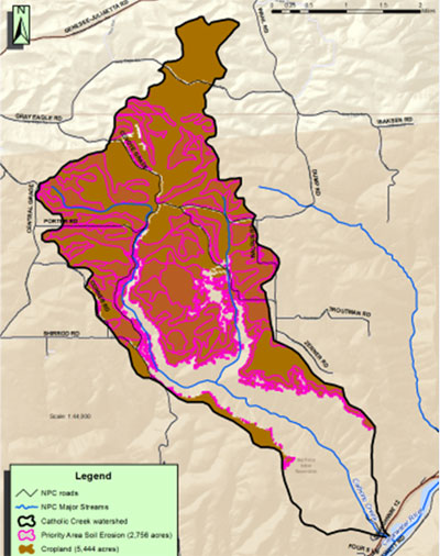
Priorities outlined in the Catholic Creek Watershed Management Plan will guide restoration efforts targeting upland areas that are actively eroding and delivering sediment to designated spawning and rearing habitats. Uplands identified as having high sediment delivery rates are those areas with a soil K factor exceeding 0.37. Collectively, these projects do not meet management criteria. Benchmarks include soil erosion rates at 1.5 times the specific soils’ tolerance rate as established by the Lewis and Nez Perce Soil Survey (NRCS, 2004), and cobble embeddedness <20%. The geographic areas with the highest susceptibility to erosion are highlighted in pink in figure 2.
Figure 2. Target Areas for Upland Sediment reductions.

Recommendations:
Treatments for this group include reduction and/or prevention of erosion within the identified critical areas. In addition to croplands, road, canyonland, and forested areas are also identified as potentially requiring treatment.
Restoration efforts should target upland areas that are actively eroding and delivering sediment to designated spawning and rearing habitats.
Treatments include the installation of erosion control measures including vegetative buffers, surface treatments, grade control structures, and water and sediment control structures.
There are an estimated 2,756 acres of high risk erosion areas. In evaluating the land treatments and management systems used within these areas, the technical team recommended that 80% of the acres be treated for sheet/rill erosion.
Deliverable 2 – Reduce Stream bank Erosion
Priorities outlined in the Catholic Creek Watershed Management Plan will guide restoration efforts targeting upland areas that are actively eroding and delivering sediment to designated spawning and rearing habitats.
Collectively, the planned sites to not meet management criteria. Management criteria are based on the NOAA Matrix of Pathways and Indicators (NOAA, 1996) for channel condition and dynamics. These indicators list streambank conditions as >90% stable, with on average, less than 10% of banks actively eroding.
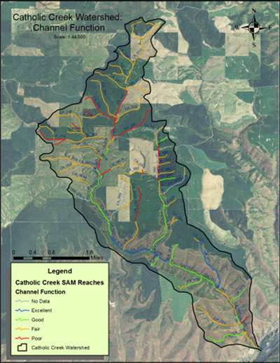
Reaches in this group are those that received a poor Channel Function rating (shown as red lines in Figure 3. Reaches receiving a Poor ranking are typically confined, often by a road prism, have little to no floodplain access, are actively downcutting or widening, and less than 50% of the reach is channelized or riprapped. Additionally, the channel may be deeply incised or have water withdrawals, with minimal flooding, and unstable banks. A total of 12.8 miles is identified for treatment.
Figure 3. Channel treatment areas.

Deliverable 3 – Reduce Stream bank Erosion
Priorities outlined in the Catholic Creek Watershed Management Plan and the Catholic Creek Road Erosion Inventory Final Report will guide restoration efforts targeting upland areas that are actively eroding and delivering sediment to designated spawning and rearing habitats. These sites do not meet the management criteria of <20% cobble embeddedness.
A road erosion inventory and assessment identified 10 treatment priorities relating to roads (Hall et al, 2012). This treatment group treats passage barriers as well as road related sediment delivery to spawning and rearing habitat. The 2012 Road Inventory and Assessment (Hall et al, 2012) identifies 10 treatment priorities relating to roads (Table 1).
Table 1: Implementation summary and treatment extent
| Priority | Description | Treatment Extent |
| 1 | Fish passage barrier culverts with high to extreme hazard ratings. | 10 Each |
| 2 | Treatments listed in priorities 3-10 that are within 200 linear feet of a stream. | Included in
numbers shown in
3 to 10 |
| 3 | Sloughing, cracking and unstable road surfaces | 5.4 Miles |
| 4 | Critical cropland buffer areas | 961 Acres |
| 5 | Unstable road bank cut/fills | 14 Miles |
| 6 | Down cutting road ditches | 2 Miles |
| 7 | Culverts with High-Extreme Hazard not in floodplain or identified as fish passage barrier | 19 Each |
| 8 | Non-critical cropland buffer areas | 172 Acres |
| 9 | Rangeland buffer areas | 74 Acres |
| 10 | Plugged culverts | 3 Each |