One of the five objectives identified in the Catholic Creek Watershed Management Plan is to restore flow.
Objective Description:
Improve stream flow regime to levels consistent with objectives in the subbasin plan, with particular emphasis on recovery of anadromous stocks. Summer base flow is limiting all focal species. Improvement in flow regime is considered critical to attainment of goals for both anadromous and resident species. Address priority problems with protection and restoration activities designed to promote properly functioning conditions where the watershed hydrograph indicates peak flow, base flow and flow timing characteristics are comparable to an undisturbed condition. Desired outcomes include improved hydrologic functions and base flows adequate for all life stages of Anadromous and resident fish. Benchmarks are noted in the deliverable descriptions for projects associated with this objective.
Deliverables:
In order to meet this objective one deliverable or treatment was identified:
Deliverable 1 – Improve watershed hydrology.
Priorities outlined in the Catholic Creek Watershed Management Plan will guide restoration efforts targeting areas with impaired hydrologic function. Collectively the planned sites do not meet management criteria. Management criteria include adequate flows for fish. This deliverable focuses on watershed hydrograph characteristics of peak flow and flow timing. Management criteria are based on the NOAA Matrix of Pathways and Indicators (NOAA, 1996) for flow/hydrology. A properly functioning condition is identified as a watershed hydrograph that indicates peak flow, base flow and flow timing characteristics are comparable to an undisturbed condition.
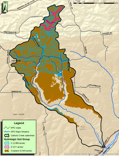
Hydrolologic conditions in the geographic priority areas are driven by upland conditions. Focus areas are restoring wetlands, restoring native vegetation, and reducing surface runoff from agricultural fields. There are 2,280 acres within the watershed with C or D soil hydrologic ratings (Figure1). These areas have the highest surface water runoff due to their soil properties.
Figure 1. Flow treatment areas.

Recommendations:
Treatments include actions that promote water retention and land surface roughness, such as: detention basins, road decommissioning, transportation planning, wetland enhancement and protection, restoration of drained lands, spring protection, vegetative plantings, and changing agricultural management practices.
Wetland enhancements will occur in springs and areas with wetland soils that have been converted either by drainage or by removal of hydric vegetation. Estimated wetland treatment areas are 15.
Upland vegetation projects will be selected in areas with a C or D soil hydrologic rating (shown as pink or blue areas on figure 1). Treatment includes planting of grass/forbs and upland trees or other treatments that increase surface infiltration rates to a minimum of 0.6 inches/hour. Estimated treatment needs include 40 acres of upland grass planting and 60 acres of upland tree planting.
Works Cited
Thompson, L. C. (2004). Fish Habitat in Freshwater Streams. San Luis Obispo County Extension, California: University of California ISBN 978-1-60107-291-7. http://anrcatalog.ucdavis.edu/pdf/8112.pdf.
iParagraph copied verbatim from Thompson, L. C. (2004). Fish Habitat in Freshwater Streams. San Luis Obispo County Extension, California: University of California ISBN 978-1-60107-291-7. http://anrcatalog.ucdavis.edu/pdf/8112.pdf.
iiParagraph copied verbatim from Thompson, L. C. (2004). Fish Habitat in Freshwater Streams. San Luis Obispo County Extension, California: University of California ISBN 978-1-60107-291-7. http://anrcatalog.ucdavis.edu/pdf/8112.pdf.