Within the fire boundary, hillslope erosion rates were identified. Data was organized into one of four categories; low (0-1 tons/acre), moderate (1-10 tons/acre), high (10-50 tons/acre), and very high (>50 tons/acre). Potential hillslope erosion was estimated using the GeoWEPP model. GeoWEPP is a geo-spatial interface for WEPP (Water Erosion Prediction Project). GeoWEPP Model Runs completed by Mary Miller, Michigan Tech Research Institute and USFS Rocky Mountain Research Station, Moscow, Idaho. Map Generated by Nikki Lane, Nez Perce Soil and Water Conservation District. June 2016.
Erosion on burned areas typically declines in subsequent years as the site stabilizes, but the rate of recovery varies depending on burn or fire severity and vegetation recovery. Soil erosion following fires can vary from less than 0.1 tons/acre (less than 0.1 Mg/ha/year) in low severity wildfire, to more than 164.6 tons/acre/year (369 Mg/ha/year) in high-severity wildfires on steep slopes (Hendricks and Johnson 1944, Megahan and Molitor 1975, Neary and Hornbeck 1994, Robichaud and Brown 1999).
Robichaud and Brown (1999) reported first-year erosion rates after a wildfire from 0.5 to 1.1tons/acre (1.1 to 2.5 Mg/ha/year), decreasing by an order of magnitude by the second year, and to no sediment by the fourth, in an unmanaged forest stand in eastern Oregon. DeBano and others (1996) found that following a wildfire in ponderosa pine, sediment yields from a low severity fire recovered to normal levels after 3 years, but moderate and severely burned watersheds took 7 and 14 years, respectively. Nearly all fires increase sediment yield, but wildfires in steep terrain produce the greatest amounts, 12.5 to164.8 tons/acre/year (28 to more than 369 Mg/ha/year). Sediment yields usually are the highest the first year after a fire and then decline in subsequent years. However, if precipitation is below normal, the peak sediment delivery year might be delayed until years 2 or 3.
Following a fire, it is often necessary to use some standard prediction technology to evaluate the risk of soil erosion. For forests that tend to regenerate rapidly, the risk of erosion decreases quickly after the first year, at a rate of almost 90 percent each year. The erosion rate depends on the climate, topography, soil properties (including hydrophobicity), and amount of surface cover. Surface cover may include unburned duff, rock, and needle cast following fire.
Methods:
The most recent erosion prediction technology is the Water Erosion Prediction Project (WEPP) model(Flanagan and Livingston 1995). WEPP is a complex process-based computer model that predicts soil erosion by modeling the processes that cause erosion. These processes include daily plant growth, residue accumulation and decomposition, and daily soil water balance. Each day that has a precipitation or snow melt event, WEPP calculates the infiltration, runoff, and sediment detachment, transport, deposition, and yield.
The Water Erosion Prediction Project (WEPP) (Laflen et al., 1991; Flanagan and Nearing, 1995) model is a continuous simulation, process-based model that allows simulation of small watersheds and hillslope profiles within those watersheds for assessing various soil and water conservation management options for agricultural, rangeland, and forest sites. The integration of orthophotos, soil surveys, land use maps, climate data, and precision farming data as well as multiple soil and land use within each sub-catchment is currently under development.
The Geo-spatial interface for WEPP (GeoWEPP) (Renschler, 2002) utilizes digital geo-referenced information such as digital elevation models (DEM) and topographical maps to derive and prepare valid model input parameters and defaults to start site-specific soil and water conservation planning for a small watershed with a single soil and land use for each sub-catchment.
Results:
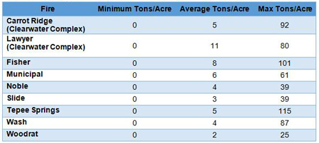
The GeoWEPP model was utilized to determine hillslope erosion for the 2015 fires. The model estimated soil erosion from less than 0.1 tons/acre (less than 0.1 Mg/ha/year) in low severity burn areas on ridges, to as high as 115 tons/acre/year in the high-severity areas on steeper slopes. The average erosion rate ranged from 2 to 11 tons/acre (Table 2). Four fires had tons of estimated erosion over 100,000 tons, Teepee Springs (597,741), Clearwater Complex (337,359), Fisher (235,778), and Wash (186,602). The Partridge Creek – Salmon River 1706020902 HUC 10 watershed had the most estimated tons of erosion (424,671). Tons of estimated erosion for HUC 10 watersheds by fire area shown in Table 1.
Table 1. Tons of estimated erosion for by HUC 10 watersheds
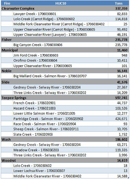
Table 2 – GeoWepp Model Estimates of Erosion Rates – First Year After Fire
References
USDA Forest Service. (2005). Wildland Fire in Ecosystems - Effects on Fire on Soil and Water. Gen. Tech. Rep. RMRS-GTR-42-vol.4.
USFS, NPSWCD. (2016). US Forest Service Rocky Mountain Reserach Station, Nez Perce Soil and Water Conservation District. GIS Layer. Idaho.