This tour is to familiarize stakeholders with Lower Lapwai Creek and District activities.
HOW TO USE: The outside covers present descriptions of each site, while the inside provides a map location of each site.
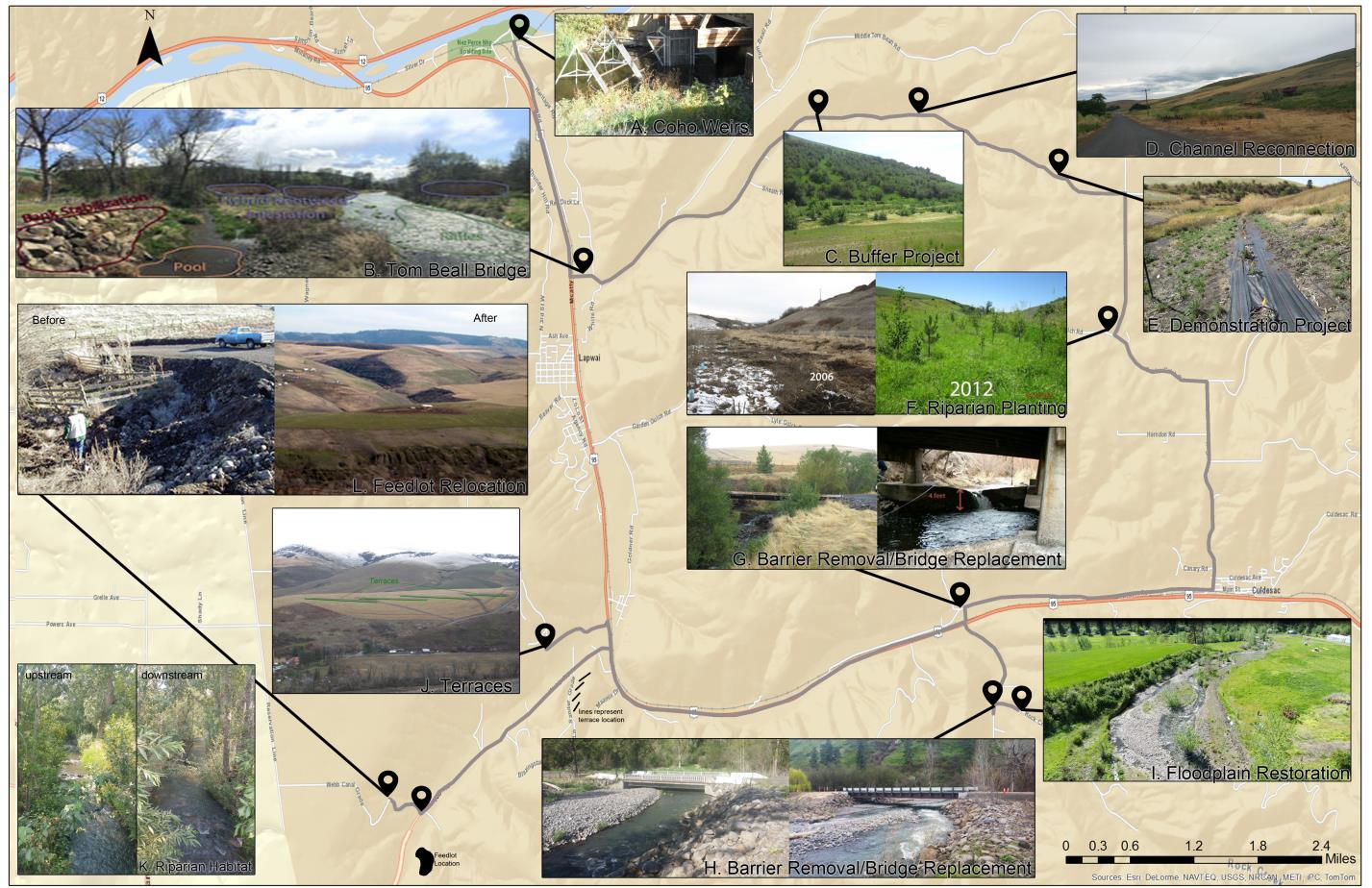
A. Coho Weirs & PIT Tag Array
This site is located near the Nez Perce Historical Park.While on the bridge over Lapwai Creek look south (upstream) where the railroad bridge crosses the stream. In the fall the Nez Perce Tribe builds temporary weirs to collect and rear coho salmon eggs. You can also see the PIT Tag Array. This PIT Tag Array detects the movement of fish in and out of the system. In the Lapwai Creek system there is one at the mouth of Lapwai Creek, Sweewater Creek, and Mission Creek. To see the data visit the PTAGIS website.
B. Tom Beall Bridge
From site A head south on Watson Store Rd toward Spalding Ave. In 0.3 miles turn left onto US-95. In 2.0 miles turn left onto S. Tom Beall Rd. This site is located along Lapwai Creek where the Tom Beall bridge crosses the stream. The project work extends upstream along the southeast bridge abutment (look for rocks along banks). Prior to the installation of the rock riprap the stream was eroding behind the bridge abutment. The goal of this project was to reduce sediment delivery to Lapwai Creek and prevent further degradation of the bridge abutment. This site was a cooperative project with Nez Perce County and the Nez Perce Soil and Water Conservation District. Also at this site look upstream and you can see bank stabilization, deep pool (where fish rest and hide from prey), riffle (where water races over rocks and oxygen is incorporated in the water, bank stabilization features installed to protect the bridge abutment), and a hybrid knotweed infestation (a noxious weed).
C. Buffer Project
From site B head east on S Tom Beall Rd. In 1.1 miles stay right. The site is in 1.8 miles. This site is located along South Tom Beall Creek and is an example of vegetative plantings. The site is a 1.25 mile long stream segment without an adequate vegetative buffer. Plantings are installed within the riparian zone or the transition zone between aquatic and upland habitat within South Tom Beall Creek floodplain. The goal of this project is to assist in restoring the floodplain to properly function conditions, provide wildlife cover and forage enhancement, erosion control and soil stabilization through a reduction in run-off, and reduce stream temperatures. This site is a cooperative project with two private landowners and the Nez Perce Soil and Water Conservation District. The black fabric is used for weed control until the plants are established.
D. Channel Reconnection
From site C head east on S Tom Beall Rd. The site is in 0.9 miles. This site is located on South Tom Beall Creek and is an example of a floodplain reconnection project. The channel was moved in the late 1970s as a part of a road improvement project, resulting in 1,200 feet of channelization. The goal of this project is to restore the stream channel to its historic channel by installing 2 culverts and returning the stream to its natural channel. The existing channel erodes into the roadbank causing safety concerns and providing sediment and increased turbidity to the stream. This site is a cooperative project with 3 private landowners, Nez Perce County and the Nez Perce Soil and Water Conservation District.
E. Demonstration Project
From site D head east on South Tom Beall Rd. The site will be in 1.5 miles. The demonstration project began in 2012 as part of an effort to identify the best techniques for the restoration of heavily infested poison hemlock vegetation sites. Restoration projects adjacent to streams and springs in the Lapwai Creek watershed are necessary to improve steelhead habitat along the streams. Springs within the lower Lapwai system contribute significantly to lower stream temperatures and have been documented to be areas of high juvenile steelhead densities. The majority of the springs are heavily infested with invasive species. In order to restore native vegetation to these ecosystems the noxious and invasive plants need to be suppressed. The field trial and demonstration will focus on poison hemlock control and revegetation. The NPSWCD identified poison hemlock as one of the top three weeds (along with reeds canarygrass and knotweed) to control prior to restoration.
F. Planting Project
From site E head east on S Tom Beall Rd, in 0.7 miles turn right onto Misner Road. This site will be in 1.4 miles at the intersection of Misner Road and Garden Gulch Road. This project is located on Garden Gulch and was installed in 2006. Riparian tree, shrub, and grass plantings act as a buffer between developed or agricultural land and streams. Riparian planting improves water quality by reducing soil erosion and absorbing and filtering nutrients that cause water pollution. Trees and shrubs also provide habitat for wildlife and stream shading, which reduces the impact of solar radiation on water temperatures.
G. Barrier Removal & Bridge Replacement
From site F head southeast on Garden Gulch Rd, in 1.1 miles turn right onto Cottonwood Creek Rd. Continue for 2.0 miles, then turn right onto Chambers Rd, stay right in 223 ft. Continue on Chambers Rd for 0.8 miles. This site is located on Lapwai Creek and reinstated 9.27 miles of spawning and rearing habitat. This task was completed in August 2008. The bridge barrier was removed through a joint effort of the District, land owner and the Nez Perce Tribe. The barrier was created as a result of the 1996 flood event in Lapwai Creek. The District has worked with the land owner since 1996 to remove this barrier. The District removed the barrier and the Nez Perce Tribe restored property access through the installation of a bridge.
H. Mission Creek Bridge Replacement
From site G turn right onto US-95, continue for 1.1 miles and turn left onto Mission Creek Rd. The site will be in 1.0 miles. This site replaced an existing bridge on Mission Creek that caused seasonal fish barriers due to flow restriction. The existing 40 LF bridge was replaced with a prefabricated 80 LF bridge. The existing bridge was considered a partial and/or ephemeral barrier. The bridge restricted flow causing bedload to be deposited upstream of the structure. The bedload created a lack of connectivity between the upstream and downstream segments of Mission Creek. The barrier was flow dependent, meaning that the barrier did not exist when flows rose above the bedload. Based on photo point monitoring and a review of historic bridge monitoring reports, it appeared that the barrier occurred on an annual basis with the majority of blockage occurring in the months of June through September. This seasonal barrier prevented juvenile fish from migrating upstream and downstream during the highest stream temperature months. The replacement bridge is wider than the 47 LF bankfull width and the 71 LF flood prone width allowing unrestricted flow.
I. Rock Creek Floodplain Restoration
From site H head north on Mission Creek Rd, turn right onto Rock Creek Rd in 223 ft. This project extends one mile from this intersection. The project goal is to restore the floodplain in the Mission and Rock Creek watersheds. This project will install fencing to restrict livestock access to the stream, install large woody debris to increase floodplain roughness, and install streambank protection measures.
J. Terraces
From site I turn right onto Mission Creek Rd. In 0.9 miles turn left onto US-95. Continue for 4.2 miles, then turn left onto Wild Rose Grade. In 0.7 miles pull over and look at the field to the south. This project is located in the Sweetwater Creek watershed. Four terraces were installed and contributed a total reduction of 62 tons of soil being delivered to the stream.
K. Riparian Coverage
From site J head east on Wild Rose Grade towards US-95. In 0.7 miles, turn right onto US-95. Continue for 0.3 miles, turn right onto Webb Rd. In 2.3 miles turn left onto McCormack Ridge Rd. The site is located at the bridge over Sweetwater Creek. Looking downstream of the bridge you can see a good example of fish habitat. You can locate overhanging vegetation, a well shaded stream, and large woody debris. Looking upstream of the bridge you can locate riffles, rocks for hiding, pools, and hand placed weirs.
L. Feedlot Relocation
From site K head northwest and turn left onto Webb Rd. In 230 ft turn right onto Webb Canal Grade. Continue for 0.6 miles, then look to the south. This site is located in Sweetwater Creek watershed. From this location you can see relocated feedlot, there is a metal pole barn. This is the hay storage and winter feeding area for a 55 cow operation. This used to be in the riparian area up McCormick Ridge Rd.
Lapwai Creek Self-Guided Tour